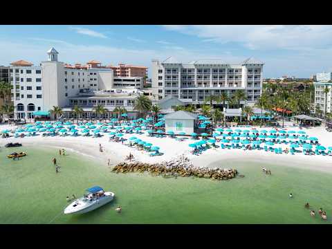
Clearwater Beach and its pier: understanding the public heart of the shore
This catalogue entry is labelled Clearwater Beach — beach and pier. Pier 60 is the destination’s principal public pier reference, but the label does not provide a surveyed installation or a verified inventory of the image. The article therefore explains the central beach and pier setting without promising a particular deck, façade or viewing direction. It is the most useful of the three entries for considering the public organisation of the shore: a landmark over the water, a park on land and the surrounding routes used by arriving visitors.
A landmark that gives the beach a centre
A long resort shore needs points of orientation, and Pier 60 fulfils that role for Clearwater Beach. The pier and adjacent park link the beach with the central arrival area. They provide a named meeting place in a setting where sand, water and hotel buildings might otherwise be difficult for a first-time visitor to distinguish.
The park and pier are related but separate spaces. A view showing the structure cannot establish access to its full length, fishing availability or the condition of individual facilities. The city’s current notices should govern a visit. This distinction is especially important on a coast where storms, repairs and operational decisions may affect only part of a familiar landmark.
Waterfront geography on two sides
The central public beach faces the Gulf, while the island’s inner side relates to Clearwater Harbor, marinas and the causeway connection. That arrangement makes the pier a seaward reference within a larger island system. Understanding which side of the island a place occupies is often more helpful than comparing straight-line distances between waterfront addresses.
The nearby marina context is associated with boating departures; the open beach has a different function. Neither should be treated as a substitute for the other. A visitor planning a cruise and time on the sand should check the actual departure point and allow for the movement between them, even when both are marketed under the same destination name.
The evening gathering
The city presents the Sunsets at Pier 60 celebration as part of Clearwater Beach’s visitor experience, with performers and vendors. The setting brings people together around the daily change in light. It is an example of a natural event becoming a social occasion through a public place and an organised programme.
A camera can suggest this changing atmosphere when the relevant area is in frame, but the programme is not guaranteed by a picture of the beach. Dates, weather decisions and access arrangements require current information. The broader idea remains meaningful even on a quiet evening: the pier gives a fixed point from which to appreciate a horizon that changes continually.
Beach Walk and the landward edge
South of Pier 60, Beach Walk is a landscaped promenade described by the city as a route with planting, artistic touches and views of the beach. It lets visitors experience the boundary between the public shore and the built resort district. Walking there can make the geography easier to understand than moving directly from a vehicle to a patch of sand.
The promenade also belongs to the city’s planning story. Beach by Design addressed the physical and economic condition of the destination and supported the development of a stronger pedestrian frontage. The public beach setting is consequently both a coastal landscape and an urban space shaped by choices about circulation, redevelopment and access.
A century of easier access
The first wooden bridge to Clearwater Beach was built in 1916 according to the municipal historical timeline. Its importance lies in the connection it created: the mainland city and the shore became more closely linked in everyday travel. The present causeway and visitor district are later expressions of that relationship.
Rather than searching only for old buildings, read the beach’s history through infrastructure. The approach roads, meeting places, commercial streets and promenade show how a natural shore became a major destination. Pier 60 is part of that public experience, serving orientation and recreation in a city whose development has repeatedly depended on connections across water.
Reading the image and planning a walk
If the pier is visible, its structure gives a scale against which to compare the width of the beach and the changing waterline. Watch how people and shadows occupy the sand at different times, without using a single moment to predict future crowd levels. Reflections and cloud cover can transform the apparent colour of water without indicating a measurable change in its quality.
A focused first outing can combine the central park, the public beach and a section of Beach Walk. The restaurant district to the north and Sand Key across Clearwater Pass add different themes for later exploration. Those destinations provide context; they are not assumed visible. Current access information and instructions on site remain necessary for swimming, pier use and transport, whatever the image appears to show.