● LIVE
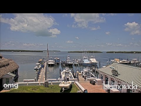
Whale Harbor: real-time view of the water, boats and maritime activity in Islamorada.
Between Florida Bay and the Atlantic, Islamorada combines fishing traditions, fossil coral, island history and coastal leisure. Four catalogue entries introduce different aspects of a destination spread across several islands.
3 webcams onlineSelect a live view: the Play button opens the dedicated page for that specific camera.
The points identify two land-based places for understanding Islamorada: a geological park and a public recreation park. They are visitor landmarks, not camera positions.
Islamorada is a village of islands in the Upper Florida Keys, not a compact town centred on one beach. Plantation Key, Windley Key, Upper Matecumbe Key and Lower Matecumbe Key form its inhabited backbone; Indian Key and Lignumvitae Key add offshore landscapes. The Overseas Highway links places that have different relationships with fishing, conservation and visitor life.
The collection names Whale Harbor, Islander Resort, a beach and Little Basin. Those labels provide useful themes without establishing precise camera mounts or promising particular landmarks in the image. Exploring the geography and history behind them makes the coast more intelligible than treating every stretch as the same tropical panorama.
History, landscape and landmarks that help interpret what appears in the live images.
Florida Bay lies on the sheltered western side, while Atlantic-facing waters lead towards the reef tract and the Florida Straits. Channels between islands connect different marine environments. Bayside and oceanside are useful local directions, but neither guarantees calm water. Mile markers along US 1 decrease towards Key West and are often more useful than street names for finding a business. Check the actual side of the road as well as the number.
The division between islands is important even when a road journey makes the village seem continuous. A museum on Upper Matecumbe and a park on Plantation Key are not two stops around one pedestrian square. Bridges and road junctions structure the visit, while the same short journey can move from an exposed shore to a more enclosed basin. Plan around clusters of places rather than the municipal name alone. This also makes the four catalogue entries more useful: they suggest contrasting settings within one destination, instead of four versions of a single beach.
Islamorada’s reputation for sportfishing comes from access to offshore waters and the shallower backcountry. Whale Harbor is one of the places associated with charter fishing. Different outings involve different boats, distances and skills; a flats trip is not interchangeable with an offshore charter. The activity also depends on local knowledge of channels and habitats. Ask operators about the intended fishing grounds, seasonal conditions and conservation practices rather than choosing only by the size of a boat.
The visitor-facing image of fishing is the catch, yet much of the culture lies in less conspicuous work: selecting an appropriate route, understanding changing weather, preparing equipment and matching an outing to the people aboard. A marina visit can make that relationship tangible without taking a charter. Respect the distinction between an area where customers gather and docks used for loading or servicing boats. For travellers who do go out, asking what the trip involves is more informative than assuming the phrase sportfishing describes one standard experience throughout the Keys.
At Windley Key Fossil Reef Geological State Park, quarry walls expose fossil coral in the limestone beneath the islands. Stone was extracted for Henry Flagler’s Overseas Railroad, linking geology to an ambitious transport project. The surviving quarry landscape gives a sea view an unexpected depth in time: ancient marine life became rock, then building material. Trails and interpretation make this a worthwhile land-based visit even for travellers who do not dive.
The quarry is especially helpful for visitors who have difficulty imagining how a flat island relates to a reef. Corals are normally associated with living colour beneath the sea; here their fossil forms can be examined in rock above it. The cut surfaces also record industrial intervention. Follow marked trails, read the geological displays and look at the remaining machinery as evidence of extraction rather than decorative objects. The Alison Fahrer Environmental Education Center brings together geology, tropical hardwood hammock and railway history, making the site a compact introduction to several layers of the island landscape.
The Overseas Railroad transformed connections with the mainland before the devastating Labor Day hurricane of 1935 damaged the line. The Hurricane Monument on Upper Matecumbe Key, dedicated in 1937, commemorates those who died. It is a memorial deserving a quiet visit, not simply a roadside photo opportunity. The Florida Keys History & Discovery Center, on Islander Resort property, expands the story through Indigenous history, pioneering families, fishing and transport. Museum access is separate from assumptions about resort facilities.
The railway should not be remembered only as an engineering triumph. Its workers and the communities along the line were exposed to an extraordinarily vulnerable coastal environment, and the memorial gives human weight to the story. After the hurricane, the transport landscape changed, with road travel becoming central to the islands’ development. Today the visitor sees an apparently straightforward highway, but museums and memorials reveal the earlier effort, loss and rebuilding behind it. Read the monument in that sequence rather than treating the current road as the timeless form of the Keys.
The History of Diving Museum explores the equipment and ingenuity that enabled people to venture below the surface. Morada Way adds galleries and the creative life of the village. Offshore, Indian Key preserves traces of a nineteenth-century wrecking settlement: salvaging stranded ships was an important business before modern navigation. Reaching an island park requires its own transport and weather planning. These attractions provide context for the webcam locations; their presence nearby does not mean they appear on screen.
Indian Key deserves more than the romantic shorthand of a pirate island. In the 1830s it was a settlement linked to the salvage economy, with homes, business activity and ambitions to compete with Key West. The ruins belong to a complicated history that also includes the violence of the Seminole-war period. A guided interpretation or the state park’s historical material helps distinguish documented wrecking from popular treasure stories. The island is not connected to the highway: landing arrangements, weather and the return journey are part of the visit, not details to settle after setting out.
Anne’s Beach, on Lower Matecumbe Key, introduces shallow coastal water and mangrove surroundings; Founders Park on Plantation Key combines bayside recreation with community facilities. These places have different access arrangements from a hotel shore or marina. Allow separate time for a museum, a park and any boat trip instead of rushing between them. Heat, thunderstorms and changing marine conditions can alter plans. Use official park information and marine advice, and keep wildlife encounters incidental rather than expected.
For a short stay, one day can centre on Upper Matecumbe’s historical and cultural places, with another devoted to a geological park or a properly arranged marine outing. Anne’s Beach is better approached as a shallow shoreline and boardwalk landscape than as a promise of deep-water swimming. Founders Park has a broader community role, with sports and recreation alongside its bay setting. Verify the facilities needed by your party rather than assuming every park, resort and beach provides the same combination of shade, changing space and access.
Islamorada’s habitat information describes mangrove wetlands, saltmarsh and buttonwood transition zones, upland communities and extensive marine habitats. This matters because the most valuable coastal scenery is not always the palest sand. Mangroves occupy the boundary between land and water, while seagrass belongs to the shallow marine system. A natural shoreline may look irregular or densely vegetated rather than cleared for leisure. Understanding that variety changes the way a visitor reads a basin or beach view and helps explain why public routes and marked launch points are preferable to improvised access through vegetation.
Wildlife should be approached as part of that habitat, not as a scheduled attraction in front of a lens. A bird using an ordinary shore or a fish moving through shallow water belongs to a wider system that may extend well beyond the visible area. Keep a respectful distance and follow local instructions at parks and launches. A quiet image need not mean a lifeless place, and a conspicuous animal does not establish that sightings will recur at the same time each day.
Little Basin offers a useful counterpoint to the offshore fishing image. The municipality identifies a kayak launch at Green Turtle Hammock Nature Preserve that reaches the basin through a short mangrove tunnel. The preserve also introduces tropical rockland hammock on land. Together these environments illustrate how a single outing can move from woodland to a narrow vegetated passage and then to more open water. Check the launch and route arrangements for the equipment and experience of your group; the presence of a launch is not a guarantee that every condition suits a paddle.
This is a visitor connection with the named basin, not a proposed camera location. The distinction allows the map and articles to be useful without pretending the catalogue supplies more precision than it does. The same approach applies to the unnamed beach entry: use the guide to identify real public places for an outing, then confirm the particular destination independently. A geographic guide can enrich a view while remaining clear about the limits of the location label.
Whale Harbor directs attention to charter fishing and a channel between islands; Islander Resort connects holiday accommodation with a historical museum; the beach entry raises questions about shore ecology and access; Little Basin opens a bayside perspective. Their value is complementary. Comparing them encourages attention to the distance between a working waterfront, an organised resort shore and a more enclosed coastal basin. None should be used as a forecast for the whole village.
Light and weather can also vary between exposures. A reflection that disappears at one shore may remain vivid at another, while a quiet basin may coexist with rougher water outside it. Use the pictures to appreciate atmosphere and changing rhythms. For an actual outing, obtain dated park information, operator guidance and appropriate marine conditions separately. That combination makes Islamorada both more interesting to watch and easier to visit thoughtfully.
The different live views make it possible to compare districts, light, visibility and city movement at the same moment. The guide grows with the archive, keeping each webcam connected to the place it actually shows.