
 ● LIVE
A live view from Dorsoduro, Venice’s art district, where canals, rooftops and lagoon light introduce a quieter side of the city between the Accademia, Zattere and Punta della Dogana.
Watch Venice in real time across the Grand Canal, St Mark’s Basin, Dorsoduro and Cannaregio. Each webcam adds a different perspective on lagoon light, water traffic and everyday city life.
5 webcams onlineSelect a live view: the Play button opens the dedicated page for that specific camera.
● LIVE
A live view from Dorsoduro, Venice’s art district, where canals, rooftops and lagoon light introduce a quieter side of the city between the Accademia, Zattere and Punta della Dogana.
 ● LIVE
The Grand Canal seen from Trattoria Povoledo, a few steps from Santa Lucia station: water buses, taxis and working boats move through one of Venice’s busiest stretches of water.
 ● LIVE
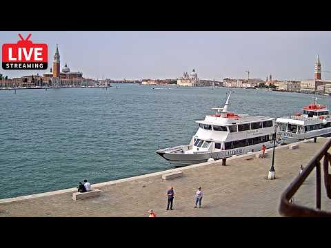
A wide live panorama over St Mark’s Basin from the Castello waterfront, with the San Marco skyline, Punta della Dogana, San Giorgio Maggiore and the meeting point of Venice’s great waterways.
 ● LIVE
A live view from the Castello waterfront across St Mark’s Basin, with the Salute, the San Marco skyline and the constant movement of boats along Riva degli Schiavoni.
 ● LIVE
A live view of Ponte delle Guglie and the Cannaregio Canal, one of the busiest gateways between Santa Lucia station, the Jewish Ghetto and the heart of Venice.
The map connects the live viewpoints with the districts, canals and lagoon spaces described in the guide.
The webcams collected on Webcam OK show Venice from several complementary viewpoints: Dorsoduro, the Grand Canal near Santa Lucia, St Mark’s Basin and the Cannaregio Canal at Ponte delle Guglie. Seen together, these live views reveal something that a single postcard cannot: Venice is not one monument surrounded by water, but a complex city whose streets, transport routes, neighbourhoods and public spaces are inseparable from the lagoon.
Each camera has a different scale. On the Grand Canal, boats and public transport dominate the scene. From St Mark’s Basin, the city opens onto a broad lagoon landscape where domes, bell towers and islands are read across the water. At Ponte delle Guglie, the view is closer to everyday movement between the railway station, Cannaregio and the historic Jewish Ghetto. Dorsoduro adds a quieter urban perspective shaped by art, residential streets and the southern light of the Giudecca Canal.
This guide is designed to help you understand what the webcams are showing, how the different parts of Venice connect to one another and what changes are worth watching in real time.
History, landscape and landmarks that help interpret what appears in the live images.
Venice developed within a lagoon environment made up of islands, channels, mudflats and shallow waters. UNESCO describes Venice and its Lagoon as an inseparable whole: the city grew through a long process of adapting settlement, navigation and architecture to a fragile aquatic environment. The historic centre is spread across many small islands connected by bridges and divided by canals that function as true urban arteries.
This relationship with water explains why Venice looks so different from other European cities. Palaces often present their most important façades toward a canal because the water was historically the principal route for people, goods and official arrivals. Even today, public transport, deliveries, emergency services, taxis and much of the city’s working life depend on boats.
A live webcam is particularly useful here because it restores movement to the architecture. A façade on the Grand Canal is not just a beautiful background: it stands on a transport corridor. St Mark’s Basin is not simply an open view: it is a junction between major waterways. Ponte delle Guglie is not only a bridge: it connects pedestrian movement with one of Cannaregio’s principal canals.
The historic centre is divided into six sestieri: Cannaregio, Castello, Dorsoduro, San Marco, San Polo and Santa Croce. This division is much more than an administrative curiosity. Each sestiere has a different relationship with water, monuments, tourism and residential life, and the webcams make those differences visible.
Cannaregio is one of the main gateways for those arriving by train and is also a large residential district with the Jewish Ghetto, the Cannaregio Canal and long pedestrian routes toward Rialto. Dorsoduro combines major cultural institutions with quieter canals and the open waterfront of the Zattere. San Marco contains the city’s most famous monumental core, while Castello stretches east from the Doge’s Palace toward the Arsenale and the Biennale gardens.
Because the cameras are distributed across several of these areas, moving from one live view to another is almost like changing urban scale: from neighbourhood life to monumental scenery, from narrow canals to the open basin, and from busy transport routes to calmer residential zones.
The Grand Canal is the principal waterway through the historic centre. Its broad reverse-S course is lined with palaces, churches, hotels and former merchant residences built over many centuries. The webcam near Santa Lucia station is especially useful because it looks onto a part of the canal where the transport function is impossible to ignore.
Vaporetti, water taxis, delivery boats and private craft use the same water corridor for very different purposes. Their wakes overlap and continuously change the surface of the canal. Around the station area, pedestrian movement is equally intense: people arriving by train immediately enter a city where the first major street they encounter is made of water.
Watching this webcam for several minutes is more informative than looking at a still photograph. The frequency of boats changes through the day, the reflections alter with the light, and rain or fog can transform the depth of the view within a short time. It is one of the clearest live examples of Venice as a functioning city rather than a static historic setting.
The webcams overlooking St Mark’s Basin reveal a completely different Venice. Here the enclosed scale of canals and calli gives way to a wide sheet of water framed by some of the city’s most recognisable landmarks. The San Marco area, San Giorgio Maggiore, Punta della Dogana and the mouth of the Grand Canal can all become part of the same visual system.
This was historically one of Venice’s great ceremonial and maritime spaces. The Doge’s Palace and the Piazzetta face the water, while the basin connects the Grand Canal, the Giudecca Canal and routes toward the Lido and the wider lagoon. The result is a panorama where architecture and navigation are equally important.
The two St Mark’s Basin webcams in the archive are valuable precisely because their viewpoints are not identical. One can emphasise the broad lagoon composition; another can bring passing boats and the Riva degli Schiavoni waterfront closer to the foreground. Comparing them helps show how much a few hundred metres can change the perception of the same monuments.
Piazza San Marco is the only major public space in Venice formally called a piazza; most others are known as campi or campielli. The monumental complex around it includes the Basilica di San Marco, the Campanile, the Doge’s Palace and the buildings that frame the square and Piazzetta.
From the water, however, the composition expands. Across the basin, the great dome of Santa Maria della Salute marks the Dorsoduro side near Punta della Dogana. The church was commissioned after the plague of 1630 and designed by Baldassarre Longhena. Its location was chosen to create a powerful architectural presence where the Grand Canal meets the broader waters of the basin.
This relationship is especially easy to understand through live images. The monuments are not isolated objects: they form a sequence around water. Depending on haze, sun and cloud, some elements become dominant while others almost disappear into the atmospheric depth of the lagoon.
The Ponte delle Guglie webcam brings the view down from the monumental scale of San Marco to the everyday rhythm of Cannaregio. The bridge crosses the wide Cannaregio Canal along a route used by residents and visitors travelling between Santa Lucia station, Lista di Spagna, Strada Nova and the inner city.
This area is also close to the historic Jewish Ghetto, established by the Venetian Republic in 1516. The Ghetto remains one of the most important places for understanding the social and religious history of Venice, with synagogues, memorials and a distinct urban form shaped by centuries of restricted space.
In the live view, the interest lies in the overlap between pedestrian traffic and water traffic. Public boats, smaller craft and people crossing the bridge create a scene that changes minute by minute. Early morning can feel very different from the middle of the day, and wet paving after rain can alter the brightness of the entire image.
Dorsoduro offers another perspective on Venice. The district includes the Gallerie dell’Accademia, the Peggy Guggenheim Collection, Santa Maria della Salute, Punta della Dogana, Campo Santa Margherita and the Zattere waterfront. Yet it is not defined only by museums and monuments: university buildings, residential streets and small canals give it a strong local character.
The southern edge of Dorsoduro faces the Giudecca Canal and receives a more open kind of light than many narrow streets in the centre. For this reason, changing weather can be especially visible in a Dorsoduro webcam. Bright sun sharpens terracotta roofs and façades, while mist and low cloud soften the relationship between buildings and the lagoon.
Dorsoduro is useful in the Webcam OK collection because it prevents Venice from being reduced to San Marco alone. It reminds the viewer that the historic city is a network of neighbourhoods, each with its own pace, landmarks and relationship with the water.
The most obvious element is boat traffic, but the type of movement matters. A vaporetto follows a public transport route; a water taxi moves differently; a service boat may stop for deliveries; smaller craft respond more visibly to wind and wake. These differences make the waterways readable in much the same way that traffic patterns reveal how a road is being used.
Light is the second major element. Venice is strongly affected by reflections from water, pale stone, brick and plaster. A clear winter morning, a hazy summer afternoon and a rainy evening can produce three completely different versions of the same view. The transition toward sunset is particularly noticeable in the open basin and along the wider canals.
Water level and weather can also change how public spaces are perceived. Tides are part of the lagoon’s normal cycle, while episodes of acqua alta may affect low-lying areas under particular conditions. A webcam can show the visual situation at a specific moment, but it should not replace official tide forecasts or civil protection information.
Finally, look at human activity. Some views are busiest because they lie on major visitor routes, while others show a more residential rhythm. Comparing several webcams at the same time is often more useful than judging the whole city from one crowded or quiet location.
The Cannaregio cameras suggest a route from Santa Lucia station through Ponte delle Guglie and the Jewish Ghetto, continuing along quieter fondamenta or toward Strada Nova and the Grand Canal. This is a good introduction to the contrast between Venice’s arrival zone and its residential fabric.
From Dorsoduro, an itinerary can link the Accademia area with the Peggy Guggenheim Collection, the Salute, Punta della Dogana and the Zattere. The route moves repeatedly between narrow streets and broad openings onto the water, reproducing the visual contrasts seen in the webcam.
The St Mark’s Basin views naturally lead toward Piazza San Marco, the Doge’s Palace, Riva degli Schiavoni, San Zaccaria and, farther east, the Arsenale and the Biennale area. Across the water, San Giorgio Maggiore provides another viewpoint back toward the city.
For a wider understanding of the lagoon, Murano, Burano and Torcello add three very different island environments. They are not simply extensions of the historic centre: each has its own history, architecture and relationship with lagoon life. Their value is greatest when they are understood as part of the same wider system that made Venice possible.
A photograph selects one instant. A webcam shows duration. This distinction is especially important in Venice because so much of the city’s character depends on water, movement and atmosphere. A canal may be almost empty and then become busy within minutes. A distant church can be perfectly clear in the morning and disappear into haze later the same day.
Live video also makes scale easier to understand. On St Mark’s Basin, the distance between the waterfront and San Giorgio Maggiore becomes perceptible through passing boats. At Ponte delle Guglie, the relationship between bridge, canal and pedestrian route becomes obvious only when people and boats are moving at the same time.
For this reason, Webcam OK treats the live stream as the beginning of the page rather than the entire content. The guide adds the geographical and historical context needed to interpret what the camera is showing.
There is no single best hour. Early morning often offers quieter pedestrian spaces and softer light. The middle of the day shows the city at its most active, particularly around transport nodes and the main visitor routes. Late afternoon can produce warmer façades and stronger reflections, while evening introduces navigation lights and illuminated monuments.
Weather is just as important as the clock. Fog is capable of reducing the depth of the lagoon dramatically; rain changes stone surfaces and reflections; clear air can make distant architectural details much easier to distinguish. Checking several cameras during a change in weather is one of the best ways to understand how varied Venice can look in a single day.
Before a visit, webcams can help you see the current atmosphere, but opening hours, transport changes, tide forecasts, access rules and event information should always be checked with the relevant official services.
A single camera can show a beautiful place. A collection of cameras can explain a city. Venice is a particularly strong example because the five viewpoints in the archive cover several distinct urban situations: a major canal, an open maritime basin, a neighbourhood bridge and an art district.
Seen together, they reveal the transition from enclosed streets to open lagoon, from tourist landmarks to everyday transport, and from monumental architecture to residential neighbourhoods. The city becomes easier to understand as a connected system rather than a sequence of isolated attractions.
As new Venice webcams are added to the archive, this guide can grow with them. The aim is not to repeat the same description under every stream, but to give each new viewpoint a precise role in the larger picture of Venice.
The different live views make it possible to compare districts, light, visibility and city movement at the same moment. The guide grows with the archive, keeping each webcam connected to the place it actually shows.