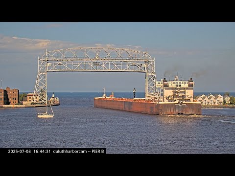
Duluth - Baia live
The bay webcam provides a broader reading of the Duluth-Superior harbor. Water, ships, tugs, haze and light help reveal the scale of the basin and general port conditions.
Duluth, Superior and the Lake Superior harbor
Duluth and Superior together form one of the Great Lakes' most important port systems. The harbor sits at the westernmost end of Lake Superior, where the St. Louis River spreads into protected water behind a long natural sand barrier.
The Port of Duluth-Superior is North America's farthest-inland freshwater seaport and connects the Midwest with the Atlantic through the Great Lakes-St. Lawrence Seaway. Webcams make this geography visible through canals, docks, freighters, tugs and open lake water.
Iron ore, grain and Great Lakes freighters
The Port of Duluth-Superior handles tens of millions of tons of cargo each year. Iron ore is the dominant commodity, joined by coal, limestone, grain, cement, salt and project cargo.
Great Lakes lakers and oceangoing vessels arriving through the Seaway are among the most dramatic webcam subjects. Their size changes the scale of the entire frame and makes the port's industrial role immediately visible.
Minnesota Point and Park Point
Minnesota Point, commonly called Park Point, is the long sandbar separating much of the harbor from Lake Superior. It is widely described as the world's longest freshwater sandbar and is reached by crossing the Aerial Lift Bridge.
Protected harbor water lies on one side and open Lake Superior on the other. This contrast helps explain why wind, waves and visibility may differ sharply between nearby cameras.
Lake Superior, wind and seasons
Lake Superior is the largest of the Great Lakes by surface area and strongly influences local weather. Spring water remains cold for a long time, summer temperatures near shore are moderated, while autumn and winter can bring powerful storms, snow, ice and difficult marine conditions.
Webcams are excellent for following this behavior. A clear day can reveal an enormous horizon; fog, snow or wind can quickly reduce visibility. The change is immediately obvious at the canal and piers.
Pier B, Minnesota Slip and the working harbor
Pier B and Minnesota Slip bring the viewer closer to the working scale of the harbor. Basins, docks, railway connections, tugboats and cargo vessels show how tightly maritime and land transport are connected.
These cameras are especially valuable during vessel maneuvers or active port operations. After dark, dock lights and reflections create a completely different visual character.
How to read Duluth through its webcams
The eight streams work best as one system. Ship Canal and Canal Park show vessel arrivals and the bridge; Pier B and Minnesota Slip show the working harbor; the bay provides context; the lighthouse shows marine conditions; Fairlawn extends the story across to Superior.
During navigation season, watch vessel movement and maneuvers; at sunset, reflections and waterfront lights become important; in winter, snow, ice and wind transform the scene. In Duluth, weather and port activity are always connected.
What this live view reveals
The bay webcam provides a broader reading of the Duluth-Superior harbor. Water, ships, tugs, haze and light help reveal the scale of the basin and general port conditions.
What to watch live
Watch vessel traffic, bridge activity, water, wind, visibility, light and seasonal change.