Duluth - Canale e porto live
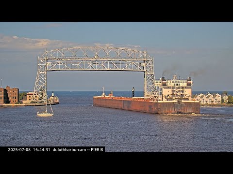
The canal webcam follows the point where vessels pass between Lake Superior and the inner harbor. It is one of the best views for watching large lakers, maneuvers, water conditions and the moment the Aerial Lift Bridge rises.
The Duluth Ship Canal
The Duluth Ship Canal opened in 1871 to create a direct route between Lake Superior and the inner harbor. Cutting the canal separated Minnesota Point from the rest of the city and created the need for a permanent crossing.
Today the canal is one of the finest places on the Great Lakes to watch large vessels enter and leave port. Live cameras capture approaches, bridge passages, water conditions and crowds along the piers.
Aerial Lift Bridge: Duluth's landmark
The Aerial Lift Bridge began in 1905 as an aerial transfer bridge with a suspended ferry platform. Growing automobile traffic eventually made that system inadequate, and in 1929-30 it was converted into the vertical lift bridge seen today.
The bridge rises to allow large vessels through and is still used daily by vehicles, cyclists and pedestrians. It is Duluth's defining landmark and the visual anchor of Canal Park webcams.
Canal Park and the visitor waterfront
Canal Park surrounds the ship canal, piers and lift bridge. Former industrial buildings and warehouses have gradually become part of a district of hotels, restaurants, museums, shops and lakefront walks.
The webcams show the unusual meeting of working port and public space. A bulk freighter can pass only a short distance from visitors while the bridge rises and waterfront life continues around it.
Iron ore, grain and Great Lakes freighters
The Port of Duluth-Superior handles tens of millions of tons of cargo each year. Iron ore is the dominant commodity, joined by coal, limestone, grain, cement, salt and project cargo.
Great Lakes lakers and oceangoing vessels arriving through the Seaway are among the most dramatic webcam subjects. Their size changes the scale of the entire frame and makes the port's industrial role immediately visible.
Lighthouses and Lake Superior navigation
Lights at the canal entrance help guide vessels between the lake and harbor. The North Pier Light, established in the early twentieth century, is one of Duluth's most photographed waterfront landmarks.
A lighthouse webcam is also a weather view. Wind, spray, ice, waves and visibility continually change the setting; winter can be severe while summer may make the same place look almost tranquil.
How to read Duluth through its webcams
The eight streams work best as one system. Ship Canal and Canal Park show vessel arrivals and the bridge; Pier B and Minnesota Slip show the working harbor; the bay provides context; the lighthouse shows marine conditions; Fairlawn extends the story across to Superior.
During navigation season, watch vessel movement and maneuvers; at sunset, reflections and waterfront lights become important; in winter, snow, ice and wind transform the scene. In Duluth, weather and port activity are always connected.
What this live view reveals
The canal webcam follows the point where vessels pass between Lake Superior and the inner harbor. It is one of the best views for watching large lakers, maneuvers, water conditions and the moment the Aerial Lift Bridge rises.
What to watch live
Watch vessel traffic, bridge activity, water, wind, visibility, light and seasonal change.