Sterling Reef and the county-pier coast: a guide to this part of Panama City Beach
Sterling Reef belongs to the Gulf-facing holiday landscape along Front Beach Road, near M.B. Miller County Pier. This places it in a particular part of Panama City Beach: a developed beachfront where condominium accommodation sits close to a substantial public recreation area. The interest of the coastal setting is not limited to the resort itself. It also lies in the relationship between the broad sandy shore, the road behind it and the pier extending out from land. The pier is a nearby visitor landmark; its location does not establish that it appears in every camera view.
A beachfront setting with a public landmark nearby
Sterling Reef belongs to the Gulf-facing holiday landscape along Front Beach Road, near M.B. Miller County Pier. This places it in a particular part of Panama City Beach: a developed beachfront where condominium accommodation sits close to a substantial public recreation area. The interest of the coastal setting is not limited to the resort itself. It also lies in the relationship between the broad sandy shore, the road behind it and the pier extending out from land. The pier is a nearby visitor landmark; its location does not establish that it appears in every camera view.
Understanding the county pier
M.B. Miller County Pier and Russell-Fields City Pier are different structures. The county pier is in the Sterling Reef and Shipwreck Island area; Russell-Fields is farther west, opposite Pier Park. Confusing them can send a visitor to the wrong part of the coast. The county facility is listed at 12213 Front Beach Road and its pier extends approximately 1,500 feet into the Gulf. Walking out along it changes the experience of the shore: the land becomes a receding line, and the relationship between beach buildings and open water becomes easier to appreciate. Anglers and sightseeing walkers use the same structure for different purposes.
A beach seen from the water’s edge
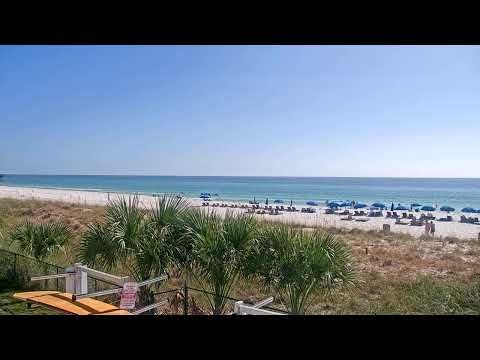
The sand around this stretch of Panama City Beach forms part of the region’s pale, quartz-rich shoreline. Small grains give the beach a different character from a pebbly shore or a rocky cove. In bright sunlight, the dry upper beach can appear markedly lighter than the wet strip reached by waves. That contrast helps explain why a narrow dark band at the waterline need not indicate a different kind of sand. Water colour also depends on light, depth, suspended sediment and surface conditions. A camera records their combined effect at a particular moment, not a permanent colour assigned to the sea.
From small holiday communities to resort buildings
The broader city developed from several beach communities, formally united in 1970: Edgewater, Panama City Beach, Long Beach and West Panama City Beach. This history is useful when interpreting Front Beach Road. The coast is not organised around a single old harbour square; it is a succession of visitor districts with different buildings, attractions and access points. Sterling Reef represents the condominium-resort chapter of that development. The place name should not be taken as evidence of a coral reef immediately offshore, and the building’s coastal address does not locate a particular camera balcony or mounting position.
What a visit to the public beach adds
Bay County lists several beach accesses, mobility mats, restrooms and a lifeguarded beach within the county-pier facility. Those facilities make this a useful place to investigate practical access rather than assuming every section beside a resort offers the same public amenities. Their operating arrangements should be checked separately from accommodation services. A beach wheelchair, a mobility mat and a fully accessible route are not interchangeable promises; visitors with specific requirements should confirm the route and assistance they need. Parking and pier use can also have separate payment arrangements, so allow time to read the current signs before heading onto the sand.
Nearby recreation with a different focus
Shipwreck Island, in the same general area, offers water-park recreation rather than a nature reserve. A family may choose to combine organised attractions with unstructured beach time, but admission to one does not provide access to the other. For a more substantial change of setting, St. Andrews State Park lies at the eastern end of the beach destination, while Camp Helen and Lake Powell are towards the western end. These are separate outings along a long coast. They belong in an itinerary, rather than being treated as scenery automatically visible from Sterling Reef.
Planning a relaxed visit to this stretch
Choose whether the priority is a pier walk, fishing, beach time or a nearby attraction before deciding where to park. A pier visit offers a view of the coast; a walk along the sand reveals its texture, gradient and access arrangements at ground level. Summer heat makes water and shade important, while thunderstorms can interrupt outdoor plans even after a bright morning. Follow posted beach flags and official water-entry restrictions, and avoid using the apparent calmness of an image as a swimming assessment. The most rewarding way to use this coastal view is as an introduction to a specific place: a resort shoreline with a working public pier district beside it.